 Atlas login
OpenAerialMap (OAM) is a collaborative platform that provides access to openly licensed drone aerial imagery. Similar to OpenStreetMap, OpenAerialMap allows everyone to contribute to and use drone and satellite aerial orthophoto imagery for free.
For years, OpenAerialMap consisted of a collection of separate orthophotos that could be downloaded and used individually. However, the situation has now changed. It has become a comprehensive drone orthomosaic for the entire world! You might be wondering, “How is that possible?” Or you might ask, “What’s the difference?” Aren’t “drone imagery,” “orthophoto,” and “orthomosaic” all the same?
Let us explain. In this section, we will give you an overview of orthophotos and orthomosaics, clarify the distinction between a regular photo and an orthophoto, and highlight the advantages of our specially developed Orthomosaic for OpenAerialMap.
Normal photo and an orthophoto
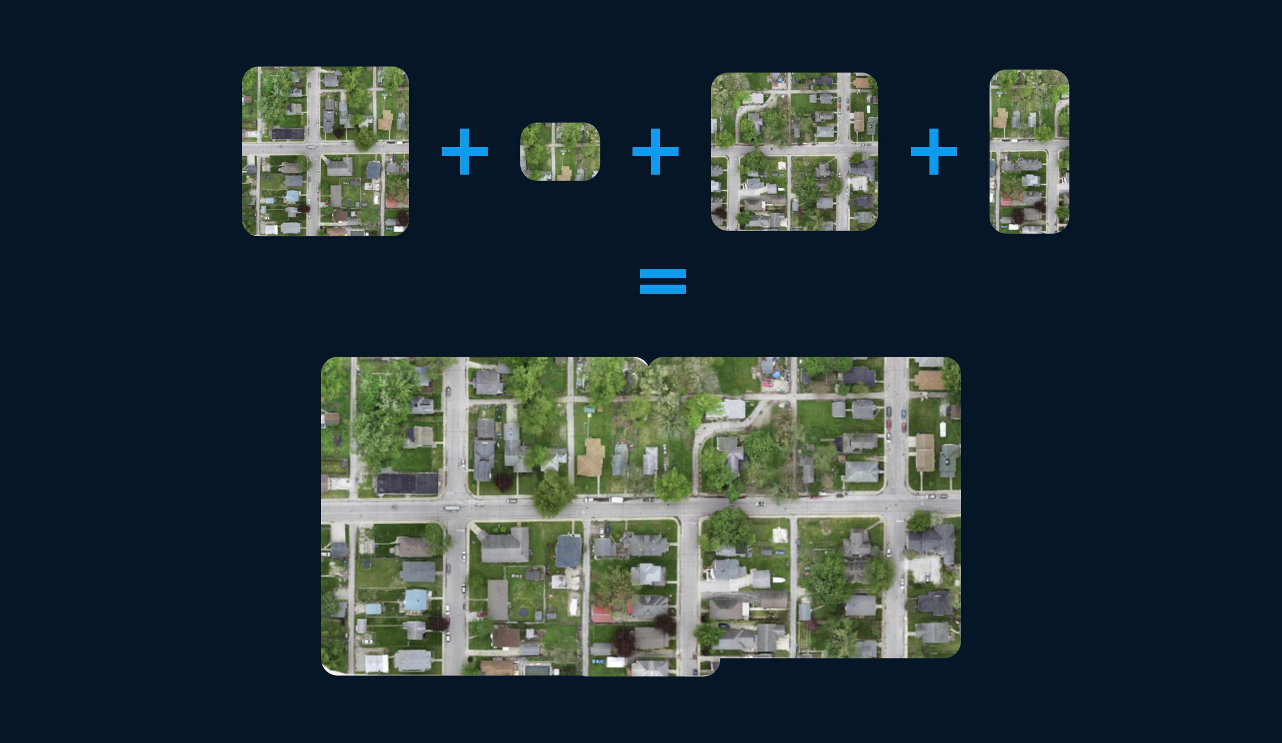
A normal photo captures a scene from the perspective of the camera, and since a drone camera looks downward at a specific angle, the resulting image appears distorted and cannot be used as a map.
Difference between a normal photo and an orthophoto:
Instead, an orthophoto is an aerial photograph that undergoes a geometrical correction process. This correction process, known as orthorectification, removes the effects of perspective, camera tilt, lens distortion, and even the influence of topographic relief. The outcome is an image that resembles a pure top-down view and is referred to as “orthorectified.”
Through this transformation, the image becomes an accurate representation of the Earth’s surface. It enables users to extract precise measurements, conduct detailed analysis, and overlay other geospatial data onto the image. In essence, such an image can be treated and utilized as a map—an orthophoto map.
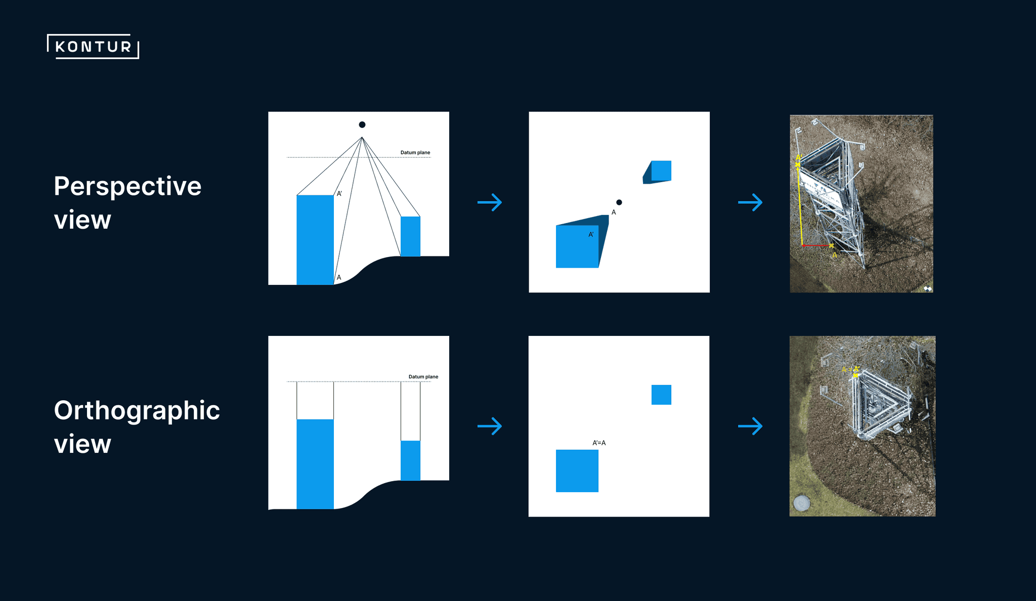
Orthophoto and orthomosaic
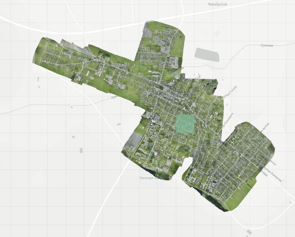
The term orthophoto refers to a single orthorectified image, while orthomosaic is a composite image created by stitching together multiple overlapping orthophotos. This process produces a seamless and highly detailed representation of a specific area.
Satellite orthomosaics, such as the ones provided by Google or Bing satellite layers, offer coverage of vast regions worldwide. However, until recently, there were no publicly available drone orthomosaics with global coverage. Drone imagery, typically captured by drone enthusiasts and shared on social networks, usually consists of images taken by a single drone during one flight.
The key distinction here is that while orthophotos are single rectified images, orthomosaics combine multiple orthophotos to form a comprehensive and detailed representation of an area.
Kontur orthomosaic for OpenAerialMap
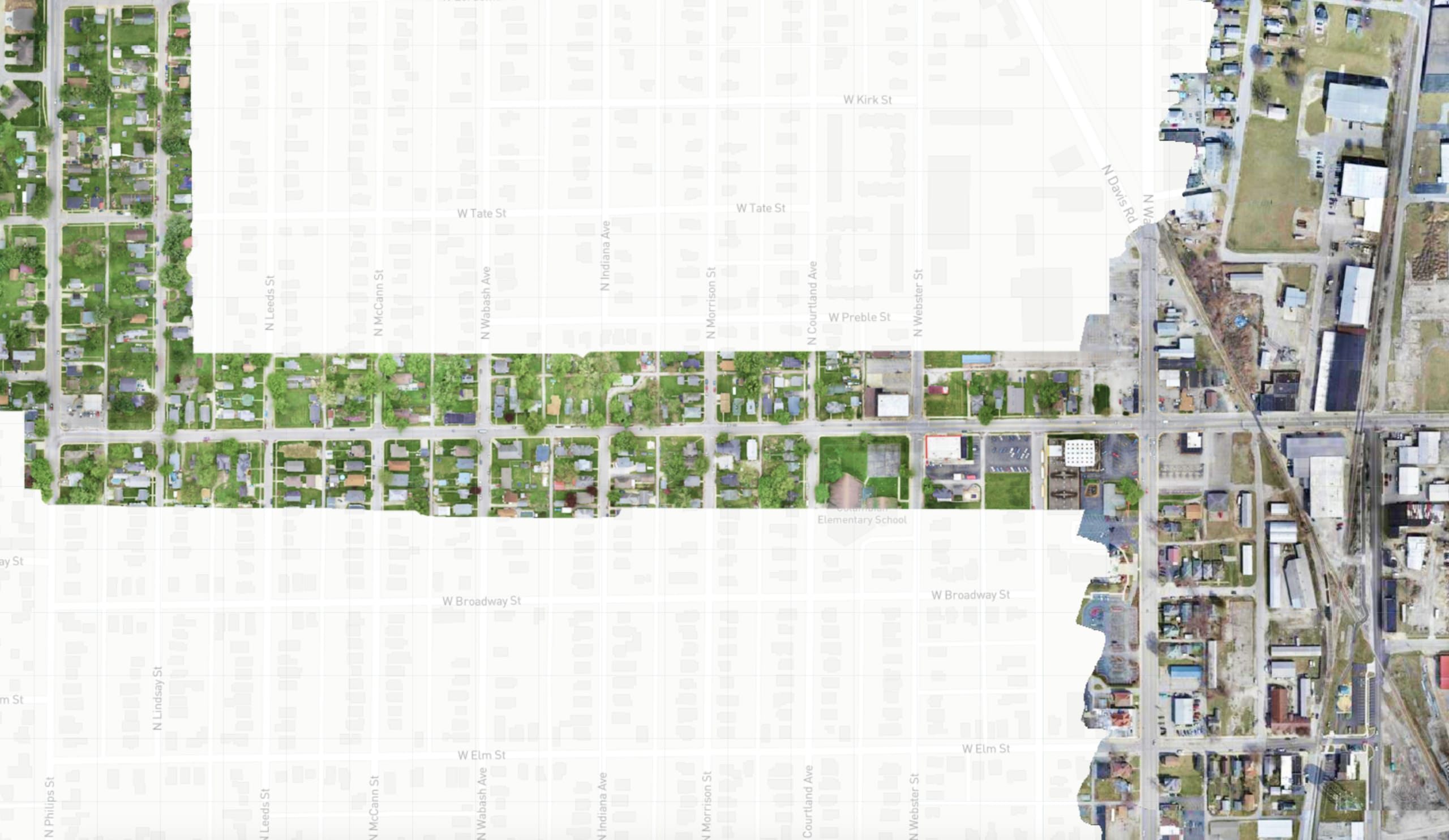
At Kontur, we are proud to offer our new product: orthomosaic for OpenAerialMap (OAM). Literally, it is the orthomosaic for the whole world. 12K+ drone images, taken by drone pilots from around the globe, are now combined into a single mosaic layer. This mosaic greatly simplifies navigation and utilization of OAM imagery.
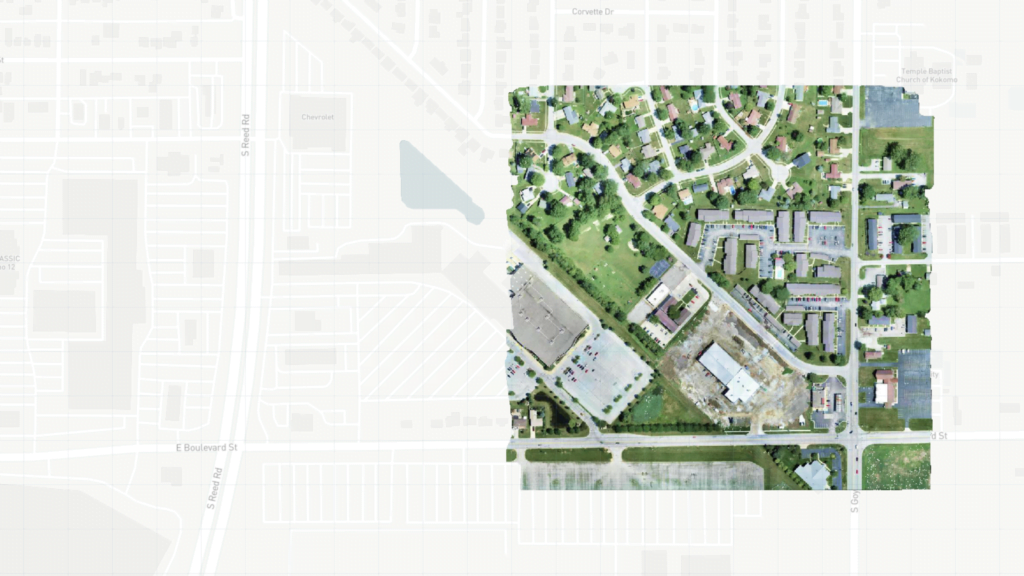
The OAM mosaic layer is designed to be highly useful in areas where OAM already has coverage, showcasing a seamless integration of multiple images to form a cohesive mosaic.
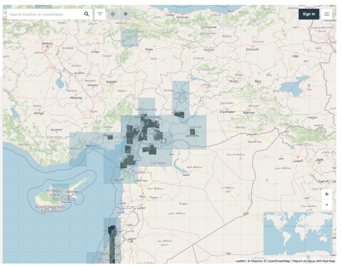
Definitely, not all the places are covered with this mosaic, but the situation here depends on you! If you want coverage to be increased, launch your drone, take photos, and upload them into OpenAerialMap.
Even in scenarios with just a few adjacent images, our OAM mosaic layer can still be much more convenient to use than individual images.
Kontur OAM mosaic layer usage
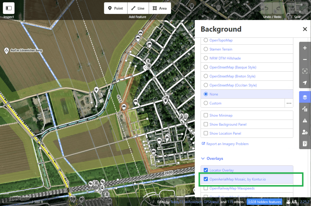
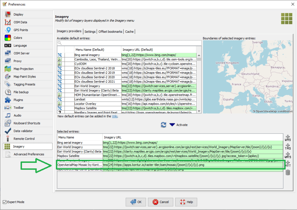
Kontur OAM Mosaic layer is available as a TMS layer, so it means that you can not only view it on OpenAerialMap website, but use it in GIS applications of your fancy: in QGIS, in popular OpenStreetMap editors like ID, JOSM, and RapID, and even in ESRI products.
Paste the following link into your GIS application:
https://apps.kontur.io/raster-tiler/oam/mosaic/{zoom}/{x}/{y}.png
Since it’s a community project, no API key is necessary. We are providing this service on a best-effort basis, if you would like to use it for your business or mission-critical usage please fill out the form at the bottom of the page.
It is already turned on in JOSM and ID by default:
ID:
JOSM:
The OAM community is continually working to improve the quality and coverage of the source OAM images. We, as Kontur, are ready to address any known issues to ensure you have the best experience possible. Feel free to provide us with your feedback, suggestions, or bug reports as we strive to enhance our product further.
How to use drone imagery?
With our free global drone orthophoto imagery, you can leverage the power of drone technology for various applications. Here are a few examples of how you can benefit from using drone imagery:
- Urban Planning and Development: Gain detailed insights into urban landscapes, analyze land use patterns, and plan infrastructure projects accurately using up-to-date orthophoto maps.
- Agriculture and Crop Monitoring: Monitor crop health, detect anomalies, and optimize farming practices by analyzing orthomosaic drone imagery captured at regular intervals.
- Environmental Monitoring: Assess changes in land cover, detect deforestation, monitor natural resources, and aid in conservation efforts using high-resolution orthophotos.
- Disaster Management: Utilize drone aerial imagery to assess damage, identify affected areas, and plan relief efforts during natural disasters or humanitarian crises.
- Archaeological Surveys: Conduct detailed surveys, document archaeological sites, and map excavations using orthophoto maps to enhance research and preservation efforts.
By accessing OAM free global drone orthophoto imagery, you open doors to a multitude of applications and possibilities. Start exploring the world from above with Kontur’s OAM mosaic layer and experience the transformative capabilities of drone aerial imagery.
Custom development requests
If you have specific requirements or need tailored drone imagery solutions for your projects, we offer custom development services.
If you have your own collection of drone and satellite images and you would like them to be published and be open to humanity, implement advanced analysis tools, or integrate open imagery into your existing workflow, our team of experts is ready to assist you.
