Atlas login
Spatial analysis has become an indispensable tool for organizations seeking a competitive edge in today’s data-driven world. The ability to extract valuable insights from geospatial data holds the key to understanding complex relationships, optimizing operations, and making well-informed decisions.
What is spatial analysis?
Spatial analysis is a systematic and powerful process that involves the exploration, modeling, and interpretation of geospatial data to derive meaningful insights and support informed decision-making.
This analytical approach focuses on understanding the spatial relationships and patterns between geographic features and their attributes. By utilizing advanced geospatial statistics and Geographic Information System (GIS) techniques, Spatial Analysis allows organizations to gain valuable and actionable intelligence across various domains.
Key aspects of spatial data analysis:
Geospatial Data Exploration
Spatial Analysis begins with the collection and organization of geospatial data, which includes information tied to specific locations. This data can encompass diverse elements, such as geographical coordinates, demographics, land use, environmental factors, and infrastructure.
Spatial Relationships and Patterns
A critical aspect of Spatial Analysis is studying the spatial relationships between different data points and identifying patterns and trends that may not be evident through traditional data analysis methods.
Geovisualization
Visualization is essential in Spatial Analysis to represent geographic data in an intuitive and interactive manner. Geovisualization techniques include thematic maps, heatmaps, and 3D visualizations, allowing users to comprehend complex spatial patterns quickly.
Spatial Statistics
Spatial Data Analysis employs specialized statistical methods that consider the spatial dependency or autocorrelation of data points. These methods help uncover significant spatial patterns and relationships, facilitating better decision-making.
Applications in different domains
Spatial Analysis finds applications in numerous fields, such as urban planning, environmental management, public health, logistics, natural resource management, marketing, social sciences, and others
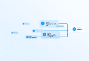
Spatial analysis by Kontur
Kontur’s Geospatial Analysis service offers a comprehensive suite of services designed to assist organizations in fully leveraging the potential of geospatial data.
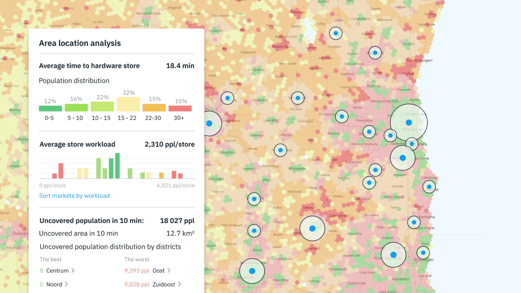
Site Selection Analysis
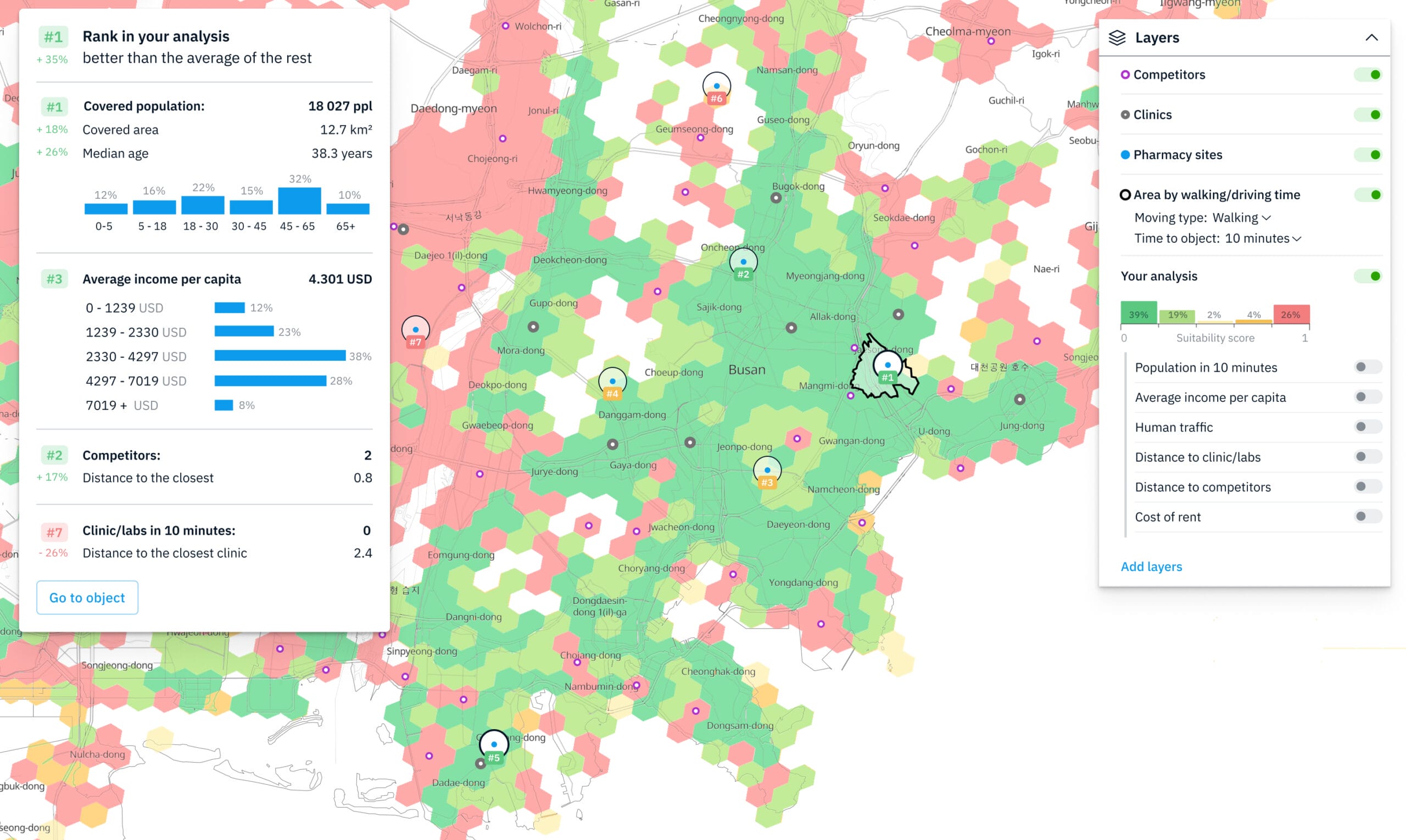
Site selection analysis is the process of identifying the best location for a business facility. This involves considering a variety of spatial data, such as population density, traffic patterns, and competition. Kontur can help businesses with site selection analysis by using geospatial data and analytical tools to identify the most suitable locations.
For example, a retail chain could use site selection analysis to identify the best locations for new stores. They could consider factors such as the population density of the area, the traffic patterns, the competition, and the availability of parking. Kontur could help them to analyze this data and identify the locations that are most likely to be successful.
Learn more about Site Selection Analysis
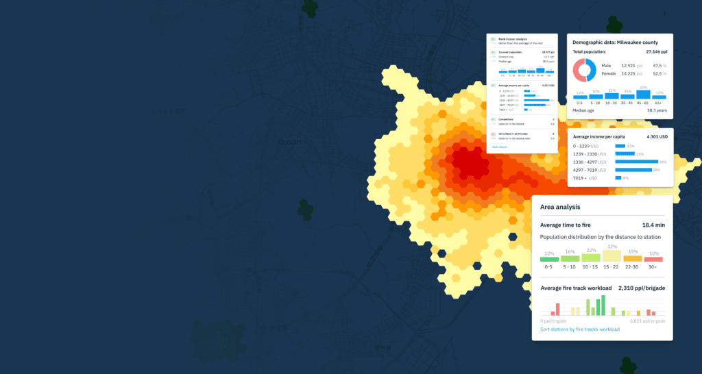
Catchment Area Analysis
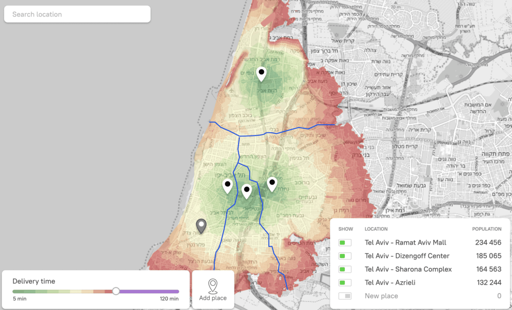
Catchment area analysis is a spatial analysis technique that helps businesses understand the geographic area that is drawn to their business. This information can be used to optimize marketing campaigns, allocate resources more efficiently, and make better business decisions.
Kontur can help businesses with catchment area analysis by using geospatial data and analytical tools to identify the areas that are most likely to attract their customers, underserved areas, competitors gaps or optimize current delivery zones.
In addition to this, Kontur can also help businesses build walking and driving catchment areas in different catch timeframes. This means that businesses can understand how far their customers are willing to travel to reach their business, both on foot and by car. This information can be used to optimize marketing campaigns and to improve the efficiency of the business’s distribution network.
Learn more about Catchment Area Analysis
Supply Chain Optimization
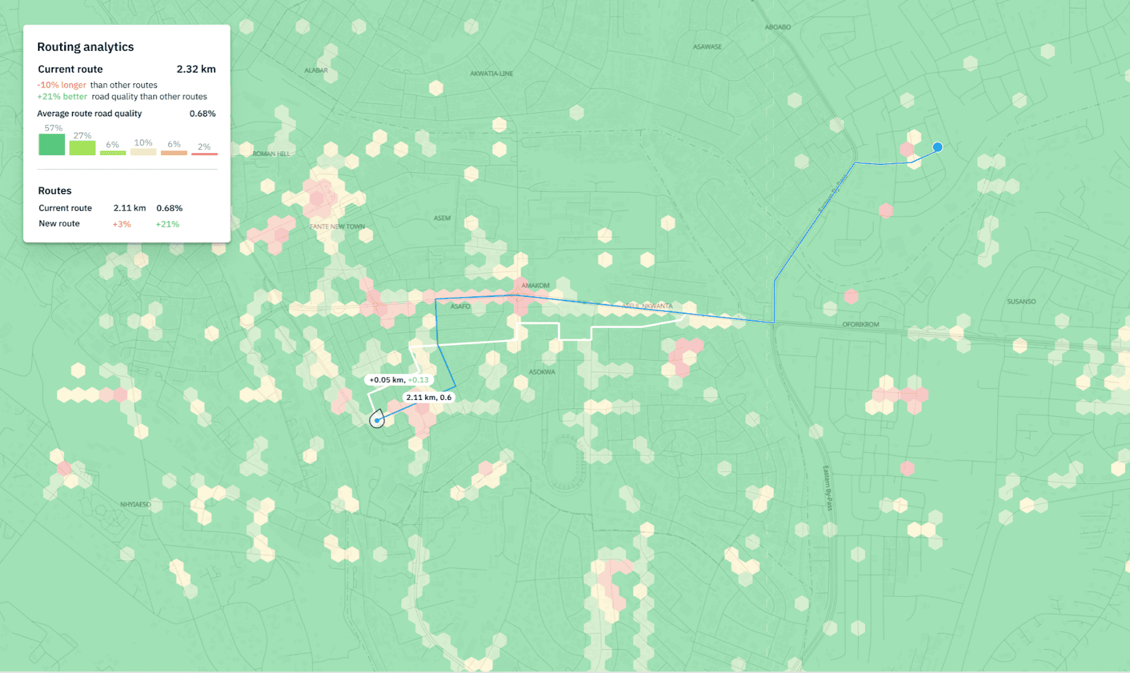
Supply chain optimization is the process of improving the efficiency of a business’s supply chain. This involves considering a variety of spatial statistics, such as transportation costs, inventory levels, and lead times. Kontur can help businesses with supply chain optimization by using geospatial data and analytical tools to identify opportunities for improvement.
For example, a logistics company could use supply chain optimization to reduce its transportation costs. They could consider factors such as the distance between the warehouses and the customers, the type of product being transported, and the current transportation rates. Kontur could help them analyze this data and identify the most efficient routes for transporting their products.
Learn more about Supply Chain Optimization
Other Geospatial Analysis
- Environmental analysis: Kontur can help businesses and organizations to understand the environmental impact of their operations. This information can be used to improve sustainability and reduce the environmental footprint.
- Healthcare analysis: Kontur can help businesses and organizations to improve their healthcare systems. This information can be used to reduce healthcare costs, improve patient care, and make it easier for people to access healthcare services.
- Emergency management analysis: Kontur can help businesses and organizations to prepare for and respond to emergencies. This information can be used to save lives, protect property, and reduce the impact of disasters.
What sets Kontur apart?
At Kontur, we stand out as pioneers in the field of geospatial analysis and risk management. Our commitment to excellence and continuous innovation has made us the preferred choice for esteemed organizations globally. Here’s what differentiates us:
- Proven Track Record: Kontur’s solutions have been extensively utilized by prominent organizations such as the Pacific Disaster Center, Humanitarian OpenStreetMap Team, SwissRe, and many others. Our success stories include effective responses to hurricanes, floods, earthquakes, wildfires, and various other disasters.
- Real-time Data Tracking: Our cutting-edge solutions allow organizations to monitor events in real-time, providing immediate situational awareness critical for swift decision-making.
- Comprehensive Data Correlation: Kontur’s sophisticated tools enable us to discover correlations and patterns within geospatial data, facilitating a deeper understanding of risks and impacts.
- Intuitive Data Visualization: With powerful visualization tools at their disposal, our clients can gain clear insights into data gaps and identify areas of potential risk effortlessly.
- Precise Risk Estimation: Kontur’s solutions help organizations accurately estimate risks and impacts, enabling them to allocate resources effectively for risk mitigation.
- Service Coverage and Areas Reachability: Our solutions assist organizations in analyzing service coverage and areas reachability, optimizing service delivery to those in need.
How to get started with Kontur’s spatial analysis services?
If you are interested in getting started with Kontur’s geospatial analysis services, please contact us to discuss your needs. We will work with you to understand your specific requirements and to develop a solution that meets your needs.
We offer a variety of ways to get started, including:
- Free consultation: We offer a free consultation to discuss your spatial analysis needs.
- Custom project: We can develop a custom spatial analysis project to meet your specific needs.
- Off-the-shelf solutions: We offer a variety of off-the-shelf spatial analysis solutions that can be implemented quickly and easily.
We look forward to working with you to help you achieve your spatial analysis goals.